

![[Copiapó 📍 Workshop] Drones en el mundo geoespacial](http://www.geocom.cl/cdn/shop/articles/POST_workshop_copiapo-Drones_en_el_mundo_geoespacial.jpg?v=1755796733&width=1080)
[Copiapó 📍 Workshop] Drones in the Geospatial World
WEDNESDAY, SEPTEMBER 10 | 09:30 AM TO 01:30 PM | HOTEL LAS PIRCAS
In this workshop, we will review the latest developments in the UAS & Drones portfolio and provide the tools to improve workflows and product quality.
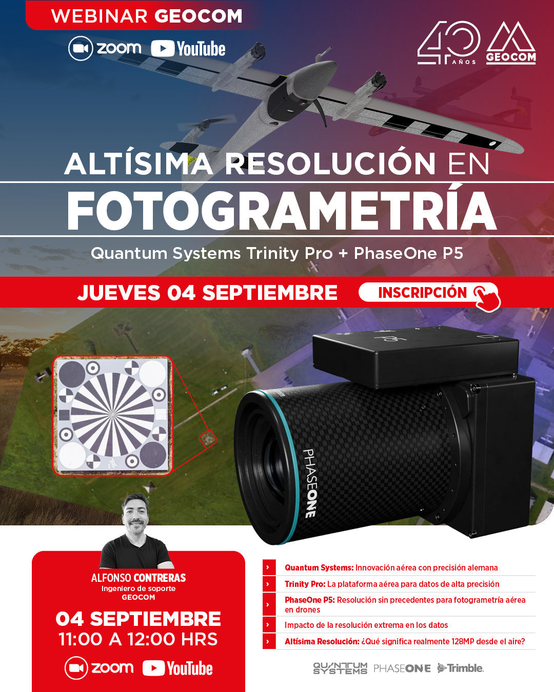
GEOCOM Webinar | Ultra-high resolution in photogrammetry: Trinity Pro + PhaseOne P5
NOW AVAILABLE! | ZOOM & YOUTUBE LIVE
In this webinar, we will discover how the combination of the Trinity Pro, one of the most advanced VTOL drones on the market, and the 128-megapixel PhaseOne P5 camera, marks the beginning of a new geospatial trend associated with high resolution.
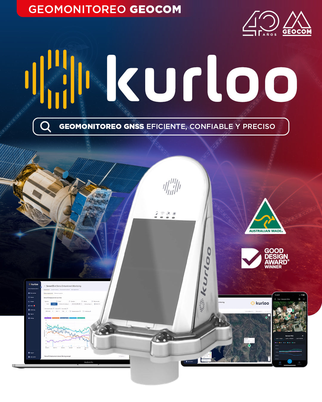
GEOCOM Launches Kurloo: The Autonomous, High-Precision GNSS Geomonitoring System
We announce the official launch and incorporation of GNSS receivers from the Australian company Kurloo into our Geomonitoring portfolio.
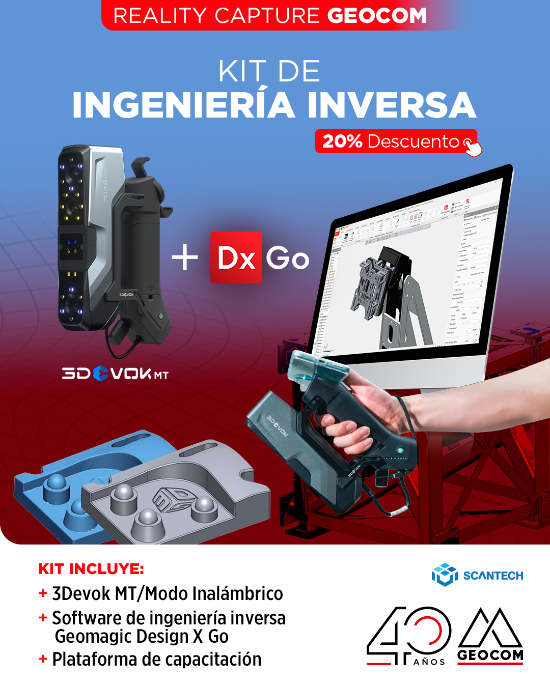
20% off promotion! Reverse Engineering Kit
We present an exclusive promotion: Geomagic DX GO software together with the Scantech 3DVoK MT portable scanner, available in a bundle with a 20% discount.

Geocom Webinar | DJI Matrice 400
![[Santiago 📍 Workshop] Procesamiento y ajuste de datos GNSS](http://www.geocom.cl/cdn/shop/articles/post_ig_WORKSHOP_Procesamiento_de_datos_GNSS_c8d3d72e-5d9e-40b8-b192-5dbe55e82871.jpg?v=1753371969&width=1080)
[Santiago 📍 Workshop] GNSS Data Processing and Adjustment
THURSDAY, AUGUST 21 | 09:00 AM TO 01:30 PM | GEOCOM STUDIES CENTER
In this workshop, we will present different examples developed with TBC (Trimble Business Center) tools to optimize the GNSS network design, processing, adjustment, and deliverables process.

Trimble Equipment Protection Plan
Trimble offers you additional coverage with Trimble Protected Plus protection plans, which include the original manufacturer's warranty (1-year sales warranty) for an additional year, in case something unexpected happens and you need to repair your equipment.
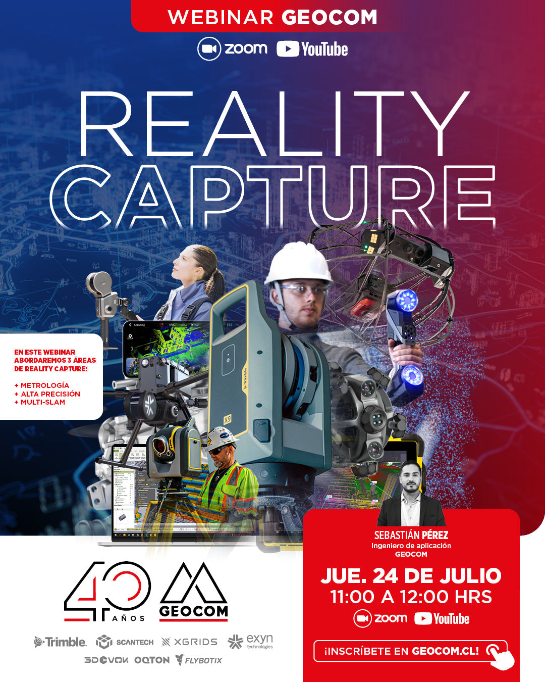
GEOCOM WEBINAR | Reality Capture
NOW AVAILABLE | YOUTUBE LIVE
In this webinar, we will address 3 areas of Reality Capture: Metrology, High Precision, and Multi-SLAM.

SkyVisor - Wind Turbine Inspection Guide
If you are managing a wind farm, why not invest a fraction of that investment to ensure maximum uptime and efficiency?
![[SANTIAGO 📍 WORKSHOP] Determinación de volumen con TBC](http://www.geocom.cl/cdn/shop/articles/post_ig_WORKSHOP_determinacion_volumen_tbc.jpg?v=1750965046&width=1080)
[SANTIAGO 📍 WORKSHOP] Volume determination with TBC
THU, JUL 17 | 09:00 A 13:30 | GEOCOM
TBC offers different possibilities for this type of determination. Whether under the umbrella of surveys carried out with GNSS and/or total station or through point cloud management, TBC allows for volume determination in a variety of scenarios, providing a powerful solution for the AECO segment.
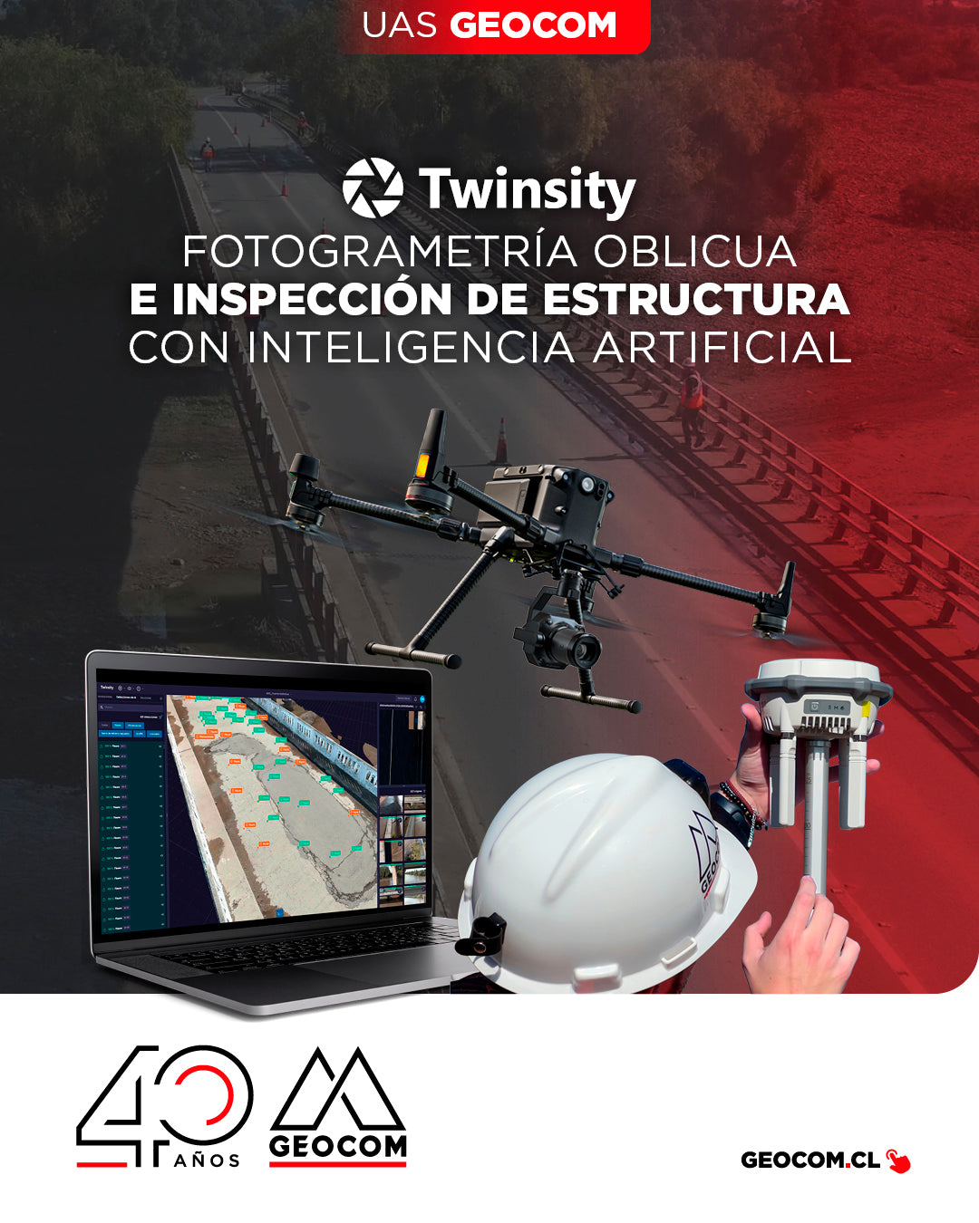
Oblique Photogrammetry and AI-powered Structure Inspection
Can you imagine inspecting a bridge with maximum precision and in less time? This is how we worked on the Naltahua bridge, where we combined the use of the Matrice 300 RTK with the Zenmuse P1 sensor, DJI Terra, and Twinspect's artificial intelligence.

NEW DJI MATRICE 400 | Intelligent and Efficient Long-Endurance Aerial Missions
GEOCOM is pleased to announce the availability of the DJI Matrice 400, the most advanced professional drone in the industry. The new standard for long-duration intelligent aerial missions is now available in the Chilean market.
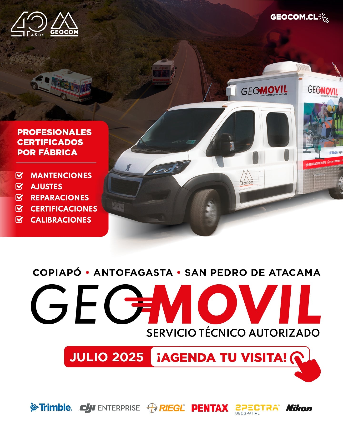
New GEOMÓVIL GEOCOM Tour - JULY 2025
Attention northern zone! We are announcing a new tour to the north of the country with our authorized on-site technical service. During the month of July we will be visiting the cities of:
📍 Copiapó 📍 Antofagasta 📍 San Pedro de Atacama
![Representación topográfica a partir de fotogrametría aérea [04 CICLO TBC]](http://www.geocom.cl/cdn/shop/articles/post_ig_ciclo_TBC4.jpg?v=1749581294&width=1080)
Topographic Representation from Aerial Photogrammetry [04 TBC CYCLE]
POST 04 | TBC CYCLE | GEOCOM Engineering
Trimble Business Center offers a number of advantages when it comes to managing the calculation of data from geometric leveling, total stations, GNSS, laser scanners, drones (photographs and LiDAR) and point clouds.
![[Evento Workshop 📍 CALAMA] Drones en el mundo geoespacial](http://www.geocom.cl/cdn/shop/articles/POST-IG_workshop_calama-Drones_en_el_mundo_geoespacial_069de5a8-1015-412b-a1f4-d31a5f2847a5.jpg?v=1751472852&width=1080)
[Workshop Event 📍 CALAMA] Drones in the geospatial world
Thank you, CALAMA!
Last Wednesday, June 18, a new "UAS & Drones in the Geospatial World" Workshop, organized by GEOCOM, was held at the Hotel Diego de Almagro.