0

Tu carrito está vacío

Altitude Geospatial

GENIUS Mini UAV LiDAR System


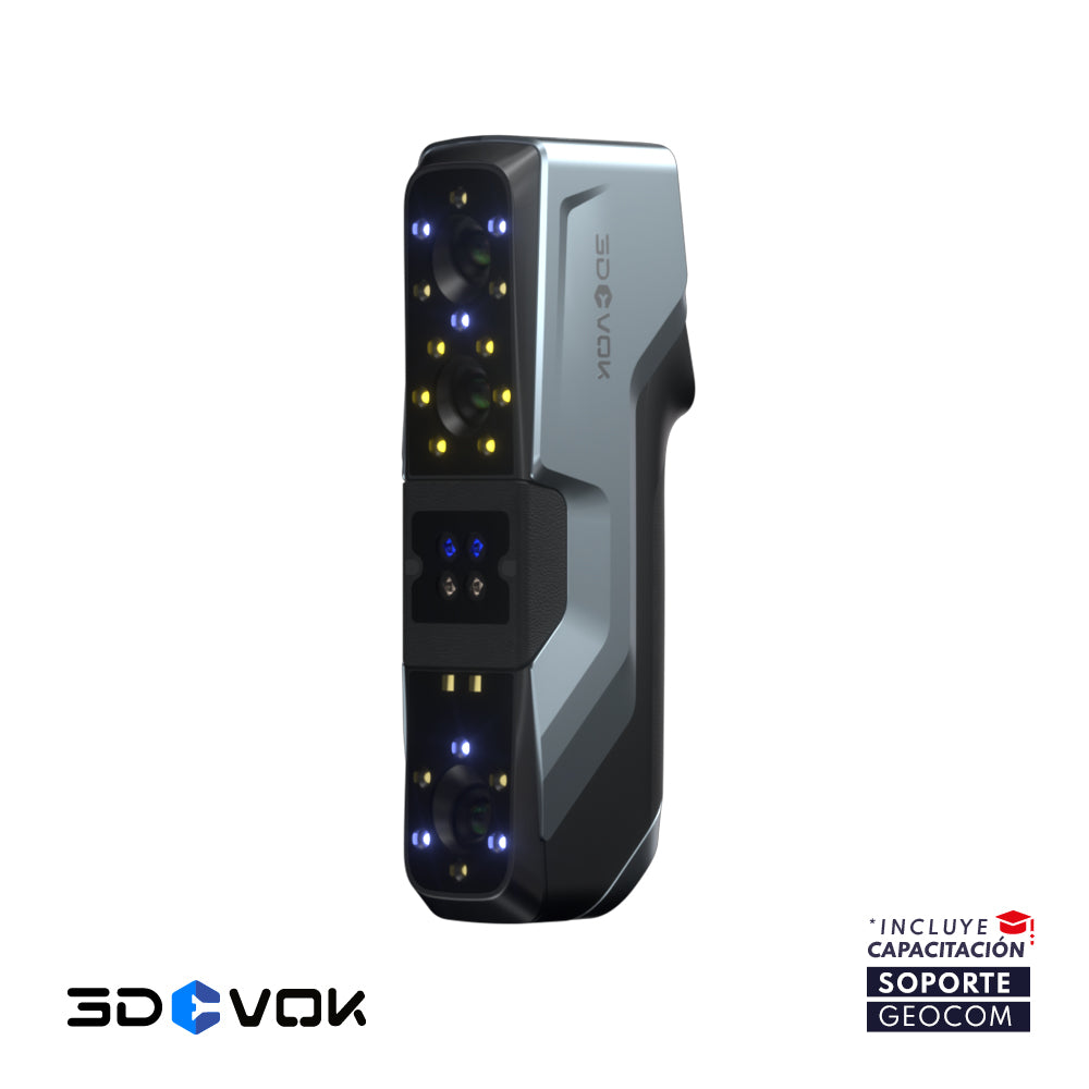
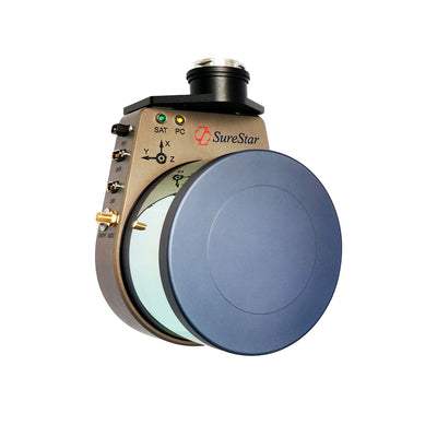
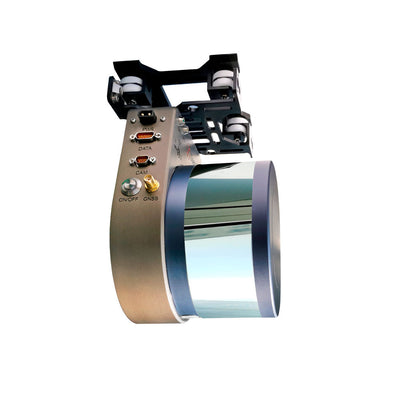
GENIUS Mini UAV LiDAR System es un nuevo sensor LiDAR (escáner láser), de pequeño tamaño y bajo peso, diseñado especialmente para ser montado en equipos UAS o Drones. Es fabricado por la empresa china SureStar, y la integración y distribución es realizada por la empresa canadiense Altitude Geospatial.

Este sistema LiDAR sensor es ultraligero (pesa sólo 1,2 Kg), altamente integrado y fácil de operar (se activa con un solo botón). Es un sistema altamente portátil, que se puede instalar directamente en Drones DJI, modelos Matrice 200 y Matrice 300 RTK. GENIUS viene integrado con un sistema inercial IMU-GNSS de Trimble Applanix, lo cual le permite obtener resultados de alta precisión (< 10 cm).

Existen dos modelos disponibles, de 16 y 32 canales, los cuales tienen el mismo peso y tamaño, debido a su diseño modular y al exclusivo proceso de ensamblaje de los componentes. El modelo de 32 canales permite obtener el doble de densidad de puntos que el modelo de 16 canales.

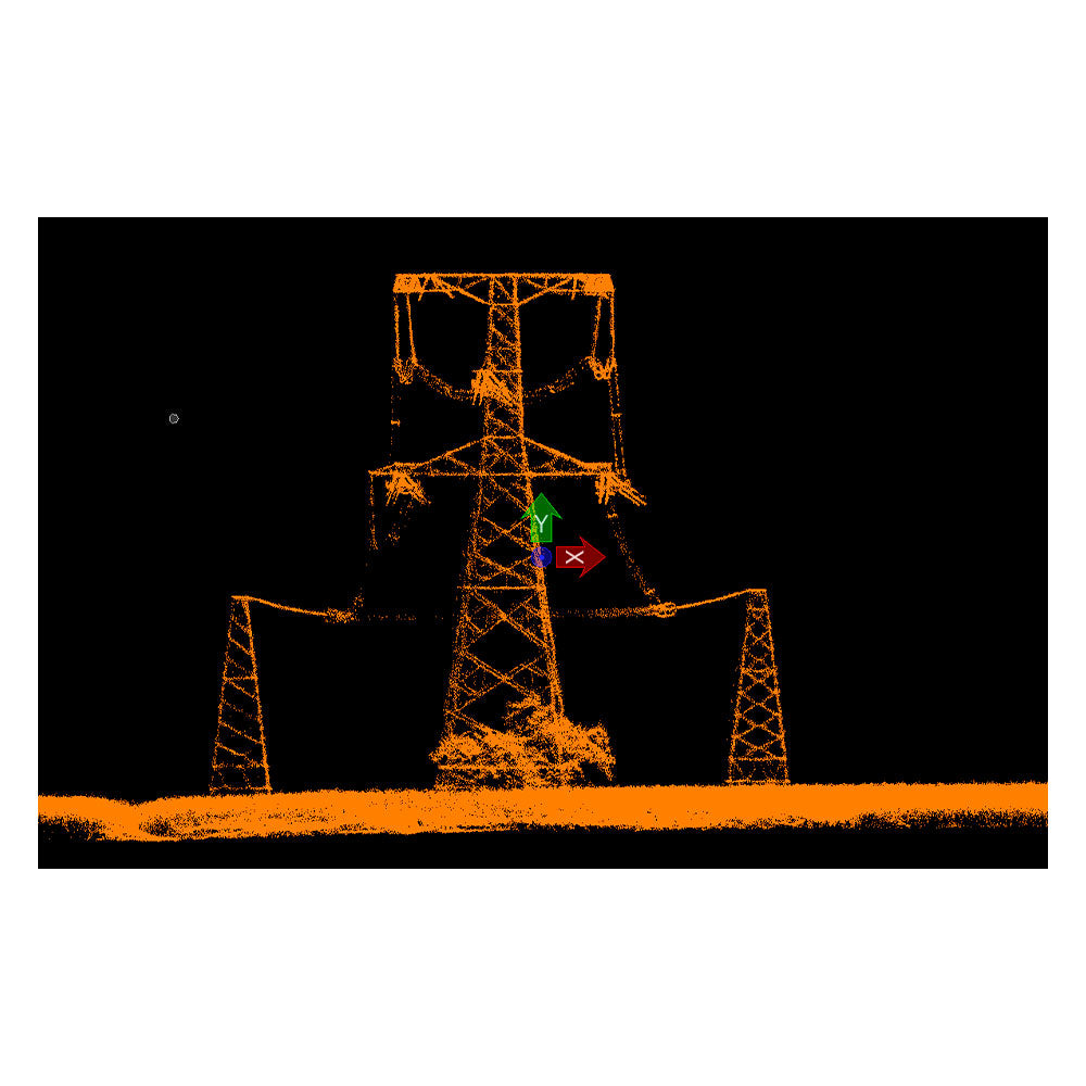
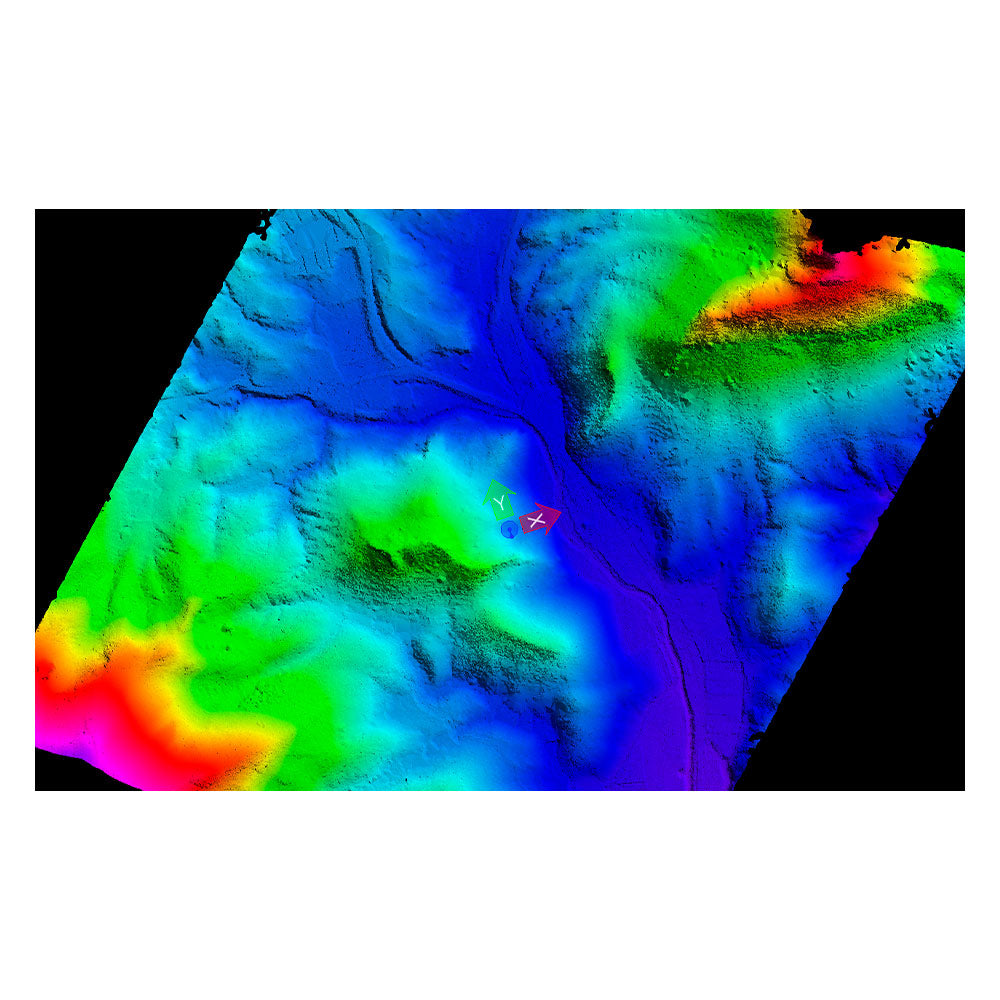
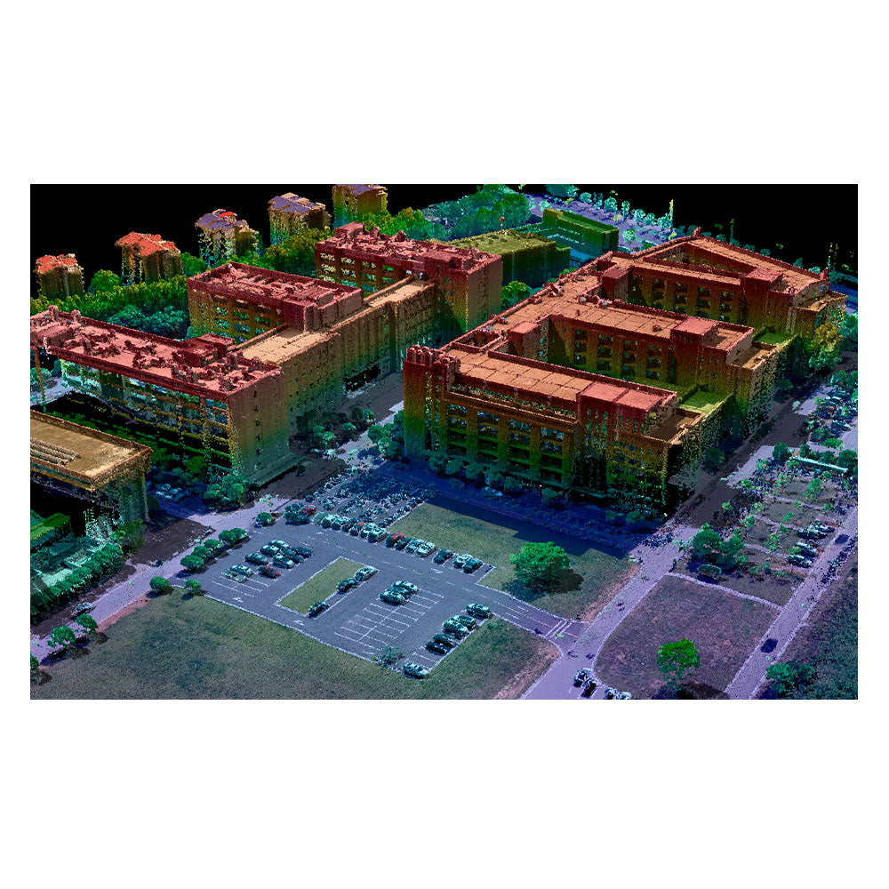
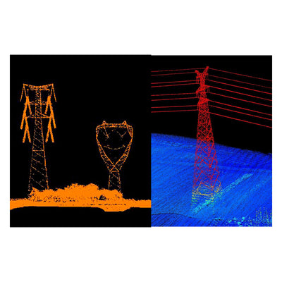
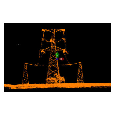
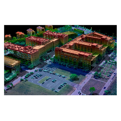
Gracias a la eficiente integración realizada por Altitude Geospatial, en cuanto a hardware y software, es posible tener un rápido flujo de trabajo en la toma de datos y posproceso, obteniendo como resultado nubes de puntos altamente densas, modelos digitales de superficie (DSM y DTM) de alta representatividad e imágenes de alta resolución.

Especificaciones técnicas del mini uav lidar

  • Modelos: 16 / 32 canales
  • Pulsos: 2 pulsos
  • Rango max. escaneo: 200 / 250 m
  • Frecuencia de pulso: 320 / 640 KHz (320.000 / 640.000 pt/s)
  • Densidad de puntos: > 100 / > 200 pt/m2
  • Precisión de escaneo: 2 cm
  • Precisión vertical: < 10 cm
  • Precisión horizontal: < 10 / 15 cm
  • Escala de mapeo: 1:500 / 1:1000
  • FOV: 360° x 30°
  • IMU-GNSS: Trimble Applanix APX UAV
  • Constelaciones: GPS L1/L2 – GLONASS L1/L2 – Beidou B1/B2
  • Softwares: POSPac UAV – UI-RF – SS-Powerline – SS-Survey
  • Peso: 1,2 Kg (1,8 Kg con cámara Sony A7III)
  • Cámaras compatibles: RGB – Infrarroja – Multiespectral – Hiperespectral 
GEOCOM es distribuidor exclusivo del sistema lidar AGI-SureStar en Chile


Suscríbete a nuestro Newsletter

Created with SnapCreated with SnapCreated with SnapCreated with SnapCreated with SnapCreated with SnapCreated with SnapCreated with SnapCreated with SnapCreated with SnapCreated with SnapCreated with SnapCreated with SnapCreated with SnapCreated with SnapCreated with SnapCreated with SnapCreated with SnapCreated with SnapCreated with SnapCreated with SnapCreated with SnapCreated with SnapCreated with SnapCreated with SnapCreated with SnapCreated with SnapCreated with SnapCreated with SnapCreated with SnapCreated with SnapCreated with SnapCreated with SnapCreated with SnapCreated with SnapCreated with SnapCreated with SnapCreated with SnapCreated with SnapCreated with SnapCreated with SnapCreated with SnapCreated with SnapCreated with SnapCreated with SnapCreated with SnapCreated with SnapCreated with SnapCreated with SnapCreated with SnapCreated with SnapCreated with SnapCreated with SnapCreated with SnapCreated with SnapCreated with SnapCreated with SnapCreated with SnapCreated with SnapCreated with SnapCreated with SnapCreated with SnapCreated with SnapCreated with SnapCreated with SnapCreated with SnapCreated with SnapCreated with SnapCreated with SnapCreated with SnapCreated with SnapCreated with SnapCreated with SnapCreated with SnapCreated with SnapCreated with SnapCreated with SnapCreated with SnapCreated with SnapCreated with SnapCreated with SnapCreated with SnapCreated with SnapCreated with SnapCreated with SnapCreated with SnapCreated with SnapCreated with SnapCreated with SnapCreated with SnapCreated with SnapCreated with SnapCreated with SnapCreated with SnapCreated with SnapCreated with SnapCreated with SnapCreated with SnapCreated with SnapCreated with SnapCreated with SnapCreated with SnapCreated with SnapCreated with SnapCreated with SnapCreated with SnapCreated with SnapCreated with SnapCreated with SnapCreated with SnapCreated with SnapCreated with SnapCreated with SnapCreated with SnapCreated with SnapCreated with SnapCreated with SnapCreated with SnapCreated with SnapCreated with SnapCreated with SnapCreated with SnapCreated with SnapCreated with SnapCreated with SnapCreated with SnapCreated with SnapCreated with SnapCreated with SnapCreated with SnapCreated with SnapCreated with SnapCreated with SnapCreated with SnapCreated with SnapCreated with SnapCreated with SnapCreated with SnapCreated with SnapCreated with SnapCreated with SnapCreated with SnapCreated with SnapCreated with SnapCreated with SnapCreated with SnapCreated with SnapCreated with SnapCreated with SnapCreated with SnapCreated with SnapCreated with SnapCreated with SnapCreated with SnapCreated with SnapCreated with SnapCreated with SnapCreated with SnapCreated with SnapCreated with SnapCreated with SnapCreated with SnapCreated with SnapCreated with SnapCreated with SnapCreated with SnapCreated with SnapCreated with SnapCreated with SnapCreated with SnapCreated with SnapCreated with SnapCreated with SnapCreated with SnapCreated with SnapCreated with SnapCreated with SnapCreated with SnapCreated with SnapCreated with SnapCreated with SnapCreated with SnapCreated with SnapCreated with SnapCreated with SnapCreated with SnapCreated with SnapCreated with SnapCreated with SnapCreated with SnapCreated with SnapCreated with Snap