


By: Ariel Silva | Support and Presales Manager | GEOCOM
Photogrammetry is a reliable measurement and interpretation technique using photographs. In mining, photogrammetry has enabled massive three-dimensional representation of open pits, as well as industrial plants and facilities for various purposes.
Until a couple of decades ago, photogrammetry was a large-scale topographical representation resource that covered entire operations with temporal resolutions that did not allow for analysis over very short timeframes. Today, this scenario has drastically changed thanks to the immediacy that drones provide in capturing photographs, leading aerial photogrammetry to become one of the most widely used techniques for topographical representation due to its advantages in precision and productivity, considering very extensive surfaces.
Photogrammetry has two main products: massive point clouds and orthophotos. Point clouds are a set of three-dimensional positions that, with a certain degree of detail, constitute a surface of interest. In the case of mining, the surface of interest can be an open pit, a waste dump, a leach pile, among others. The level of detail can easily reach a spatial resolution of a few centimeters, leading to different types of applications where data acquisition can be risky or compromised. Furthermore, photogrammetry facilitates representation in places where discrete point acquisition techniques are unproductive or simply cannot be applied. On a more qualitative level, orthophotos simplify the understanding of topographic maps by offering a detailed aerial view that actively contributes, for example, to short and medium-term mining planning.
What is photogrammetry?
Photogrammetry is simply measuring with photographs. According to the ISPRS, it is the science of making reliable measurements and interpretations through photographs, in order to obtain geometric characteristics of the photographed object. On the other hand, according to the ASPRS, it is the art, science, and technology of obtaining reliable information about physical objects and their environment, through the process of exposing, measuring, and interpreting both photographic images and others obtained from various patterns of electromagnetic energy and other phenomena. It is important to note that photogrammetry is part of the geodetic sciences given its purpose of mapping at the most diverse scales of representation. Also, during the last decade, it has had a strong impact on robotic vision given its strong connection to digital image processing (Stachniss, 2016).
Currently, photogrammetry has contributed considerably to engineering, considering the advent of drones and advances in photographic cameras, becoming a highly productive technique for massive geospatial data capture.
Photogrammetry is a technique that stands out for not having direct contact with the surface to be represented, therefore, it can be applied remotely. This is the main advantage it presents when considering exposure to sensitive materials or simply inaccessible places. Furthermore, it is relatively easy to acquire photographs in sequence and in large quantities, generating sufficiently dense points for a variety of applications. It is also a technique that can be applied dynamically with the possibility of real-time processing, as seen in the autonomous vehicle industry, for example. Finally, perhaps the most important advantage of photogrammetry is that its products are much more than geometry: orthophotos and point clouds are susceptible to human interpretation, just like an ordinary photograph.

However, photogrammetry requires a light source (which in most cases is the sun). Photographic cameras, being passive sensors, need an energy source to build the matrix arrangement that constitutes a photograph. From this perspective, shadows are unfavorable elements for photogrammetric processing, as is the impossibility of acquiring data at night. Also, like many geodetic techniques, it is affected by occlusion of the object or scene to be represented.
Stereoscopy: three-dimensional perception
The fundamental principle underlying photogrammetry is known as stereoscopy, which gives rise to three-dimensional perception. The best example to explain stereoscopy is vision: each eye collects slightly different images, which, through processing by the brain, allow for three-dimensional or depth perception. This phenomenon can be replicated in two consecutive photographs as long as there is overlap between them: it is only necessary to reconstruct the exact position and orientation at the moment they were photographed.
In the case of aerial photogrammetry, the aircraft—carrying the camera—performs a programmed flight sequence in which it captures photographs with a certain overlap. This photo capture technique can be based on time or position, depending on the characteristics of the aircraft and/or the camera in conjunction with its navigation system.
In this way, photographs are acquired following lines—better known as flight lines—which follow a direction according to the geographical characteristics of the place to be represented and, in several cases, considering the wind direction with the aim of optimizing the flight.

Finally, from a consecutive pair of photographs, called a stereoscopic pair, a triangulation is generated through the measurement of directions, enabling the determination of point coordinates in space. This process, when performed in blocks (with all photographs), is known as aerial triangulation and has been the decisive element for current photogrammetry.
Aerial Triangulation
One of the objectives of photogrammetry is to obtain, directly or indirectly, what is known as camera pose. By determining the pose, which corresponds to the position and orientation of the camera with respect to a reference system, the position of points in space derived from observations in different photographs is reconstructed.
Aerial triangulation, through a block adjustment of the photographs, allows for the determination of the camera's pose in a given reference system. In terms of computational processing, aerial triangulation is a major task since it needs to solve overdetermined nonlinear systems of equations with an extremely large number of unknowns.

Types of referencing
Aerial triangulation, upon determining the camera's pose, must be associated with a reference system. Typically, in conventional photogrammetry processes, aerial triangulation is performed relatively, meaning the camera's pose is calculated under an arbitrary reference while maintaining its shape and scale attributes.
There are two possibilities for determining the reference in aerial triangulation: direct or indirect.

Indirect referencing is what is usually done in aerial photogrammetry. This methodology requires the use of ground control points that allow for the transformation of coordinates of the aerotriangulated block. The major disadvantage of this technique is the need to position photo-identifiable markers according to geometries that allow for the convenient calculation of transformation parameters. As a response to this problem, direct referencing emerges, which measures—not determines or calculates—the camera's pose. The benefits of direct referencing are clear: a considerable reduction in control points (in some cases they can be completely eliminated) and optimization of the calculation process since it does not require solving a system of equations with so many unknowns.
Direct referencing is based on GNSS + IMU observations, allowing the camera's position and orientation to be obtained. However, it is a more complex technique. A variation of direct referencing is to only use GNSS for the incomplete determination of the camera's pose but solving the scale problem through positions.
In mining, the direct referencing method has practically become an operating standard due to its advantages in calculation. However, its main contribution is in terms of safety and simplification of the photogrammetric operation.
Final products of photogrammetry
In very general terms, the photogrammetric process culminates in obtaining two products: a point cloud and an orthophoto. Regarding the point cloud, it corresponds to a massive set of positions that represent the photographed object/terrain. A massive point cloud constitutes the first step for a highly detailed representation of reality. From the point cloud, breaklines can be traced, which are still very useful for representing open pits. However, the most important thing a point cloud offers is the creation of surfaces that allow for a series of subsequent analyses and calculations.
Regarding orthophotos, it should be said that it is a photograph with orthogonal projection (given by the coordinate system used in referencing). An orthophoto, broadly simplifying its definition, is a map with high possibilities for human interpretation. Orthophotos have revolutionized the cartographic field given that their nature is, in itself, practically a copy of reality but with metric objectives.
Topographic representation
Photogrammetry is considered, par excellence, as a technique of massive representation. Its primary objective is to obtain extremely dense points from a surface of interest. From this perspective, photogrammetry more than delivers, providing a comparative advantage over other methodologies in terms of productivity and safety.

In the case of the Ministro Hales mine, a weekly survey of the entire pit, covering an approximate area of 330 Ha, is required. The flight operation takes a total of 1 hour and 15 minutes, distributed over two flights at an altitude of approximately 400 m above ground level, which allows for a spatial resolution of 5 cm. Regarding data processing, the final product, which is used for the company's weekly planning, is obtained in no more than 5 hours. It is important to note that the direct referencing method using only GNSS is employed, which eliminates the need for ground control points to reference the aerial triangulation.
The point cloud, in geometric terms, establishes the starting point for a series of applications. From it, a surface is obtained that allows for the creation of contour lines, calculation of volumes, tracing of profiles, drawing of breaklines, among other topographic operations.
While the point cloud generates an extremely representative geometric base, the orthophoto is positioned more as a qualitative analysis element.

Volume calculation
Volumetric estimation is perhaps the most requested calculation from topographic data in the mining sector. It is clear that the accuracy of volume calculation largely depends on the accuracy of the points that constitute the surfaces, however, the fundamental element is the representativeness of the surface.
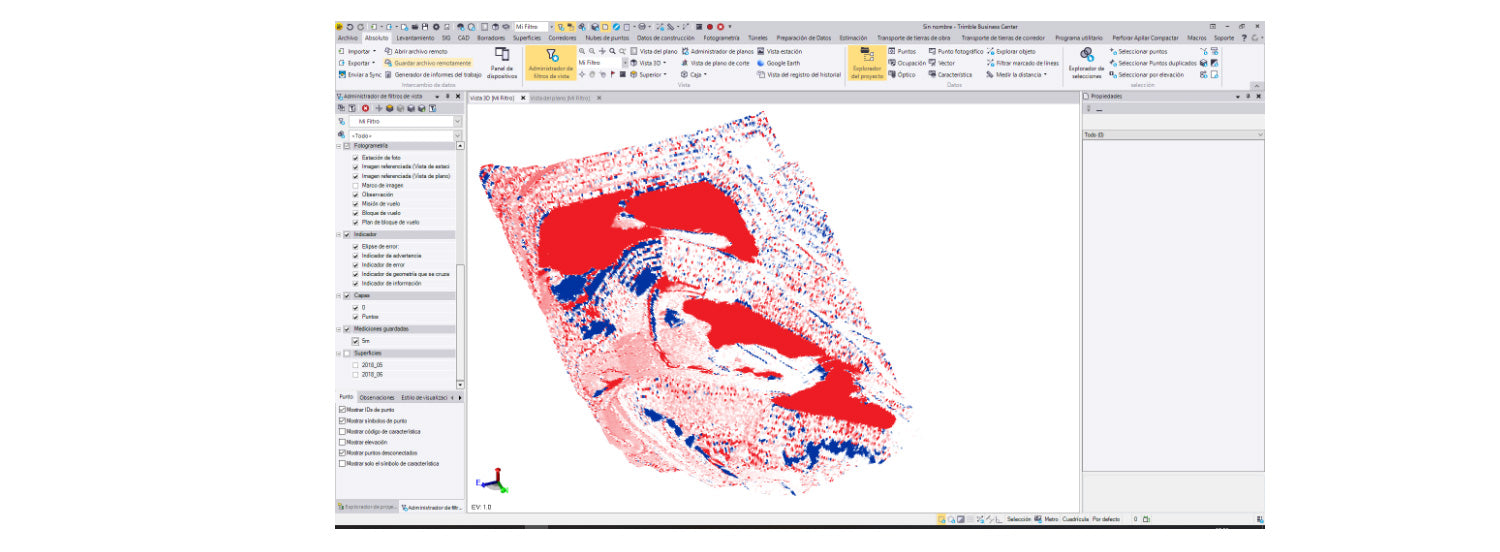
In the previous figure, a surface comparison grid obtained from aerophotogrammetric surveys with direct referencing at the Radomiro Tomic mine can be observed. The red areas are exploited areas that need to be evaluated according to the loading operation in a particular bench or phase. However, the blue areas, which correspond to spills that are difficult to represent with conventional topographic surveys, stand out. This detailed and massive representation increases the possibilities of analysis since a greater amount of evidence in topographic terms is available.
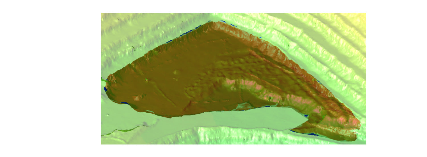
Then, to calculate by bench, only the drawing of a boundary is needed to perform the comparison between surfaces.
Road checking
Checking mining roads can be divided according to two conditions: width and slope. This task is extremely important for mining operations, as it allows for the identification of substandard situations for the correct transit of material transport equipment.

The width can be checked in the orthophoto itself by drawing two breaklines as indicated in the previous figure. This drawing is quickly done through operator interpretation. The latter is extremely interesting as it gives the orthophoto invaluable application value.
Regarding the slope, it is necessary to work directly on the point cloud to create a three-dimensional line representing the road's axis. This sequence of points will be the basis for creating a longitudinal profile. Another way to control the slope is by creating a surface and labeling the slope of each triangle.

The advantage of photogrammetry in this case is the elimination of surveying personnel on the roads, resulting in gains in safety and optimization of the loading and transport flow.
Geotechnical control
Geotechnical control is largely related to the geometry of the rock mass (without considering other types of characteristics). This geometry must remain stable over time, although it is known to be dynamic due to gravity, blasting, equipment interaction, etc.
Through the point cloud, the geometry of a group of benches can be evaluated by analyzing their height and angles from an initial perspective. In this context, there are methodologies that offer greater precision – such as a laser scanner – but which do not allow for massive surveying as the photogrammetric technique does.

Finally, it is suggested that this type of control be performed by combining photogrammetry and laser scanning techniques given the degree of influence that both techniques have to directly affect horizontal and vertical surfaces, respectively.
Tailings dam wall control
Tailings dam walls must be geometrically controlled periodically. Photogrammetric methods optimally solve the problem of representation. However, given the linear condition of a dam wall, it is recommended to carry out the survey with a multirotor using the complete direct referencing technique (GNSS + IMU). The previous cases have been developed with fixed-wing aircraft with incomplete direct referencing, i.e., only GNSS.
In this case, the west wall of the Talabre Dam was surveyed using a multirotor equipped with GNSS + IMU. A strip 4 km long and 150 m wide was surveyed in no more than one morning of work. More than 450 high-resolution photographs were obtained, in which the pose was determined directly through GNSS + IMU observations, yielding a spatial resolution product of less than 2 cm.

Conclusions
Photogrammetry has become a highly reliable technique for mapping extensive areas such as those typically found in mining. The spatial resolution achieved by its products fully satisfies most of the precision requirements offered by the mining scenario, especially those related to earthmoving.
Furthermore, the direct georeferencing technique has contributed significantly to simplifying photogrammetric operations in the field. Where a series of ground control points were previously required, today they have been almost completely eliminated.
Like all topographic representation techniques, photogrammetry must be combined with other techniques to satisfy specific requirements. However, to a large extent, photogrammetry can be used when a representation level not exceeding a few centimeters of precision is required.
Nevertheless, the great advantage of photogrammetry is not its precision, but the high level of representativeness obtained in its products. In general terms, the topographic representation tasks required in mining are only for control and inspection, that is, the comparison of engineering design with construction. In this specific area, photogrammetry is consolidated as a highly productive and safe methodology.
References
Stachniss, C. (2016). Photogrammetry I, Photogrammetry II.
ASPRS Positional Accuracy Standards for Digital Geospatial Data (2014).
Ghilani C.D., Wolf P.R. (2012). Elementary surveying. An introduction to geomatics.
Compartir:
IMPORTANT GEODETIC STATION FOR EARTHQUAKE MONITORING REINSTALLED AT THE UNIVERSITY OF CONCEPCIÓN
GEOSPATIAL DATA FOR BIM, CONTRASTING REALITY WITH DESIGN