


By Ariel Silva | GEOCOM Support and Pre-sales Manager
INTRODUCTION
The GEOCOM GNSS Network is a satellite positioning initiative that provides support infrastructure for Trimble receivers that observe code and phase in post-processing and real-time applications. This network has been operational for over a decade, starting with only one receiver installed in Santiago emitting differential corrections and recording raw files on the same receiver. Currently, the network consists of 11 Trimble reference stations observing continuously for a variety of post-processing and RTK-based applications.
Currently, the GEOCOM GNSS Network is a cooperation project between different companies and institutions that has primarily allowed for the dissemination of internet-based real-time positioning techniques through an NTRIP Caster that supplies differential corrections in CMRx format.
Its stations, like in any active geodetic network, require a
systematic coordinate calculation that allows them to be considered a reliable origin. For this reason, the GEOCOM GNSS Network is linked to SIRGAS-CON at various epochs.
GEOCOM GNSS NETWORK 2020
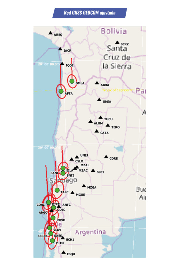
The GEOCOM GNSS Network comprises stations installed in Calama, Antofagasta, Los Andes, Santiago, Talca, Concepción, Los Ángeles, Temuco, Valdivia, Osorno, and Puerto Montt.
The products provided by the GEOCOM GNSS Network are 1-hour observation files with a 1-second recording rate. Additionally, an NTRIP Caster continuously supplies multi-constellation differential corrections in single-station and multi-station modes. This is optimized for use with Trimble Access and Trimble Business Center.
More details on accessing GEOCOM GNSS Network data can be found at https://www.geocom.cl/pages/red-gnss
FIXED POINTS: REFERENCE
The reference used for the GEOCOM GNSS Network corresponds to the weekly coordinate determination of SIRGAS-CON. According to SIRGAS, since January 29, 2017, the weekly coordinates of the SIRGAS reference frame are given under IGS14.
In this case, the weekly coordinates obtained for week 2081 (day 331 of the year 2019) are used as a reference. Therefore, the coordinate determination epoch for the GEOCOM GNSS Network is 2019.91.

PROCESSING STRATEGY
Each station of the GEOCOM GNSS Network is directly linked to SIRGAS-CON by at least 26 baselines (each connected to a SIRGAS-CON station), processing a total of 312 baselines. Regarding baseline processing, Melbourne Wübbena is used for practically all lines. Only 2 baselines were processed with Iono-Free wide lane.
Additionally, all available constellations in the observed baselines have been processed (depending on the capacity of the different receivers). Precise multi-GNSS MGEX orbits and Earth orientation parameters are incorporated into the calculation.
Out of the total baselines, 4 from the ABRA station are discarded due to providing too much noise in the vertical component determination (approximately 9 cm precision at 95%). Also, 6 baselines with precisions greater than 5 cm (95% confidence) in the vertical component are eliminated.


NETWORK ADJUSTMENT
Using 26 fixed points with SIRGAS-CON coordinate determination for the 2019.91 epoch and 906 GNSS observations, the geocentric coordinates of 12 stations of the GEOCOM GNSS Network are adjusted.
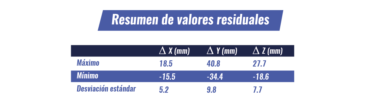
Based on the above, a network with 870 degrees of freedom (906 observations and 36 unknowns) is obtained. In general terms, the following residual values are obtained by components:
CONCLUSIONS
The coordinates of the GEOCOM GNSS Network are calculated through the weekly SIRGAS solutions. The GEOCOM GNSS Network, being an active network, requires a series of references that consider the change in positions over time due to a variety of effects on the Earth's crust. SIRGAS provides this basis with an approximate delay of 1 month.
On the other hand, sufficiently prolonged GNSS observations are required to calculate the baseline components. The length of the baseline is another parameter to consider in the calculation. For this, the GNSS processing engine must be prepared to accurately determine the components. The use of precise final orbits and Earth orientation parameters is vital for these purposes. Considering this, the length of the baseline is undoubtedly the main conditioning factor of the network design.
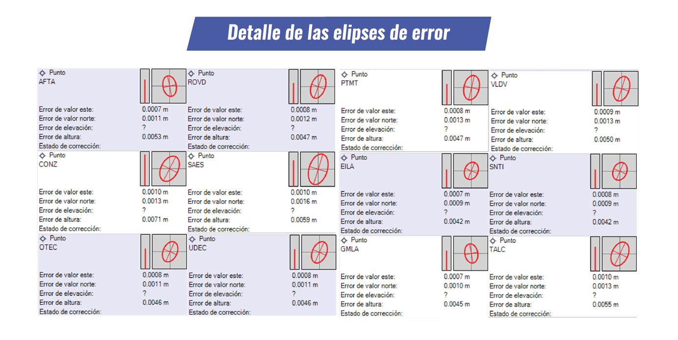
Finally, the positions of the GEOCOM GNSS Network have been calculated with an average precision of 1.4 mm in the horizontal component and 5.0 mm in the vertical component.


Compartir:
Trimble SiteVision | Augmented reality for construction
Integration of SIRGAS weekly solutions in baseline processing and geodetic network adjustment with Trimble Business Center