


TRIMBLE ACCESS v2021.20 available!
Trimble Access™ version 2021.20 is now available, offering new features and functionalities, including cloud integration enhancements, new Trimble SX10 and SX12 capabilities, object-oriented setup, an augmented reality (AR) viewer, stakeout improvements, continuous user interface and workflow modernization, plus additional options for roads, tunnels, and mines.
Other benefits include new hardware support for the Spectra Geospatial FOCUS 50 total station and Trimble EDB10 Data Bridge.
Cloud Integration
In Trimble Access, you can now browse for files and folders published to Trimble Connect and select them for download.
Selected cloud folders and files are downloaded to the Trimble Access project directory. This makes it easy to maintain the same file and folder structure across your organization's network, Trimble Connect, and Trimble Access. When updating the project, Trimble Access will identify if there have been cloud updates for the selected files and folders that need further downloading.
Users can also invite people to the project, manage who is on the project team, assign jobs to team members, and sync by tapping cloud icons.
Latest features for Trimble SX10 and SX12

The new Trimble Access allows the use of the Trimble TSC5 controller to connect to Trimble SX10 and SX12 scanning total stations for regular survey work, as well as for scanning and viewing point clouds (.rcwx files).
Trimble Access now offers two additional scan frame methods: half-dome and rectangular sides. Also new is LAS export (license required) for exporting scan point clouds and regions created with Trimble SX10 and SX12.
Object-Oriented Setup

Users can now perform an object-oriented setup for the total station in the coordinate system of an object of interest where the object's Z-axis is not aligned with the instrument's vertical axis. This setup can be used in a variety of situations, for example:
• In a manufacturing environment where the object of interest, such as a beam or concrete slab, is not flat.
• On a moving platform, such as a barge or oil rig, where the instrument cannot be leveled.
Augmented Reality Viewer
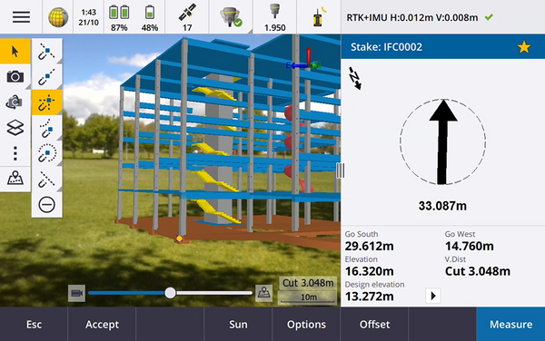
Trimble Access version 2021.20 includes the new augmented reality viewer for interacting with spatial data in a real-world context.
It includes position and orientation information provided by the connected IMU GNSS receiver and is compatible with Trimble TSC7, TSC5, and TDC600 (horizontal only). Please note that there is currently no IFC compatibility on Android controllers.
The AR viewer displays 3D map data, overlaid on the controller's camera view, and allows users to superimpose and visualize a road or building model in the real world. It also provides guidance on stakeout, captures images showing the site with superimposed features on the site, and documents important visual information, such as conflicts, for sharing with stakeholders.
Alignment Stakeout Improvements
With the new Trimble Access, alignment stakeout workflows are significantly improved by combining the traditional menu workflow with the map-based workflow.
Users can now view the map during alignment stakeout and interact directly on the map to select the alignment or stations to stake out. Now, in addition to seeing your current position and the alignment you are staking out, you can also view other map features, including DXF maps and WMS images.
Tunnels
Trimble Access General Survey and Tunnels now support viewing tunnel (.txl) files on the map, where they can be visualized in 3D and used to perform surface inspections by comparing TXL and SX12 scan data. This allows surveying and tunnel construction professionals to perform high-definition construction analysis in real time while in the field for shotcrete and excavation processes.
Additionally, the Cogo menu is now available within the Tunnels app and can be used to perform Coordinate Geometry (Cogo) functions without having to switch to General Survey. You can also access these Cogo functions from the tap-and-hold menu on the map, providing more tools to tunnel users while in the app.
Get a more detailed overview of Trimble Access improvements for tunnels here.

Mines
The Trimble Access Mines update includes improvements to automatic borehole stakeout, automatic laser line stakeout, automatic grade line stakeout, and automatic centerline stakeout, which greatly reduce operator errors and increase productivity in underground mine surveys.
Additionally, the Cogo menu is now available within the Mines app to perform Cogo functions without having to switch to General Survey, providing a simple way to access more tools in the app.

Compartir:
What's new in Update v5.60 TBC
Winners of the GeoCom 2022 Calendar Contest