

Aerial Magnetometry with Sensys MagDrone R1: Experience in detecting oversized objects in mining
What used to take days of complex walks and heavy logistics can now be solved in hours and with greater safety. We analyze how the integration of sensors into drones has changed the game for Magnetometry, GPR, Bathymetry, and many other sensors.
THE DAYS OF THE BACKPACK AND THE STAKE
For decades, geophysical exploration was synonymous with a tough test of physical endurance. Those who have been in the industry for years remember the dynamic well: long walks carrying heavy backpacks with batteries and consoles, dragging GPR antennas over uneven terrain, or holding magnetometers while struggling to maintain balance on dangerous slopes and risking operator safety.

Image 1. Terrestrial magnetometer.
Data collection was not only slow and physically exhausting but often limited by geography. A swamp, unstable tailings areas, or a cliff? They were simply blind spots or unacceptable risks for the operator. In the case of bathymetry (echosounder), the logistics of mobilizing manned boats to measure the depth of industrial lagoons or ponds added another layer of complexity and cost.
Sensors have always been powerful and have existed for many years, but the transport vehicle, i.e., the operator, was the limiting factor.
SENSORS THAT LEARNED TO FLY
The arrival of drones promised a lot, but at first, the key link was missing: professional integration. It was not enough to "hang" a sensor under a drone; precision, data synchronization, and safety were needed.
But technological advancement has been exponential. This advancement has allowed equipment to be miniaturized without sacrificing its power, enabling what once required a team of people to now take off vertically and be used autonomously and safely.
THE CURRENT SOLUTION: MAXIMIZED POWER THANKS TO SPH ENGINEERING
At Geocom, we have not only witnessed this technological transition, we have driven it. We understand that the future of exploration and mining maintenance is not about making people walk faster, but about using resources intelligently and efficiently.
Thanks to our strategic alliance and the use of SPH Engineering technologies, we have managed to integrate the most robust geophysical sensors on the market into drone platforms (UAS), breaking down the barriers that the terrain imposed on us.
![]()
AERIAL MAGNETOMETRY: We detect magnetic anomalies and buried metals (or "oversized objects") by flying at low altitude, covering hectares in minutes instead of days, with high-sensitivity magnetometers that no longer depend on the operator's passage. They can also be used in higher flights for mining prospecting, for example.
AIRBORNE GPR (GROUND-PENETRATING RADAR): We bring the ability to "see" underground to places where it was previously impossible to drag an antenna, ideal for difficult-to-access areas or ice. Very versatile for identifying unknown objects underground, archaeology, searching for pipes, wiring, geological studies, etc.
DRONE-MOUNTED ECHOSOUNDER: We replace the manned boat with a UAS system with an integrated echosounder, allowing bathymetry to be performed in toxic or difficult-to-access waters without any person touching the water. Ideal for sectors where a boat can easily run aground.
A NEW INDUSTRY STANDARD
The integration of SPH systems allows us to maximize the power of these sensors. The drone handles precise navigation (automatically following the terrain to maintain optimal altitude using an active sensor that provides the actual flight height value), while the integration system ensures that geophysical data is recorded with perfect synchronization and immediate georeferencing.
The result is clear: Greater safety for the human team, denser and more reliable data, and operational efficiency that traditional geophysics simply cannot match.
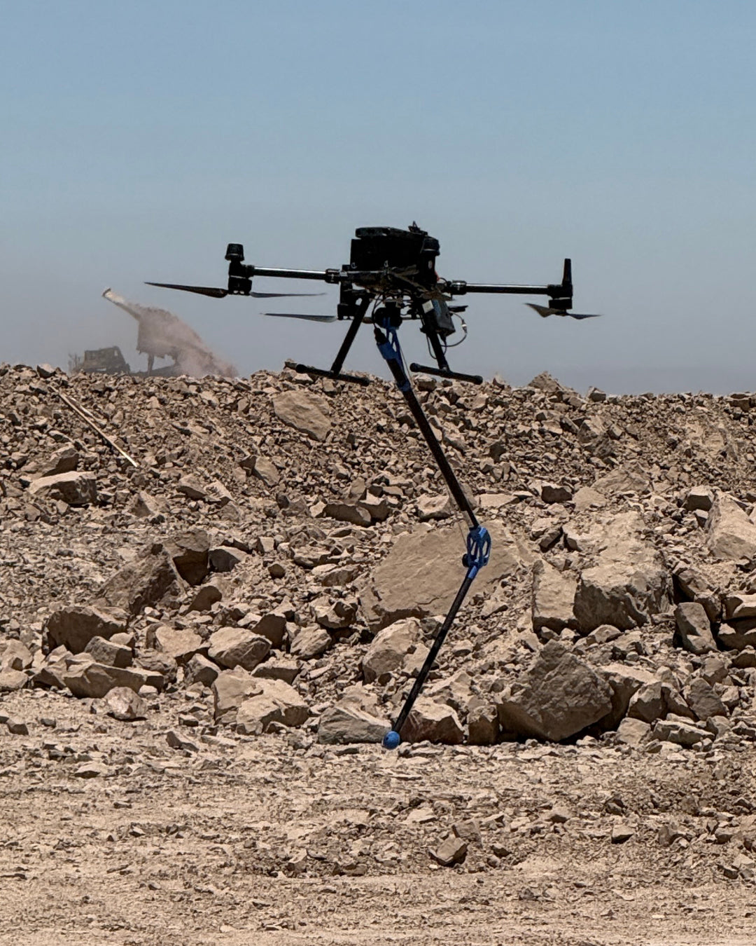
AERIAL MAGNETOMETRY: THE END OF OVERSIZED OBJECTS AND EFFICIENT PROSPECTING

Image 2. Sensys R1 Magnetometer platform mounted on M350.
The area where this technology has the strongest impact is in the detection of ferrous elements, a solution that addresses two critical fronts:
1. The Problem of Oversized Objects (Safety and Costs): Any plant operator knows that an oversized object (a shovel tooth, a track piece, or a giant bolt lost in the stockpile) is a time bomb.
- The cost of error: If one of these metals reaches the crusher, it not only implies costly equipment repair; the real pain is the lost profit. Stopping the production line for hours (or days) for emergency repairs can mean millions in losses that no operation wants to bear.
- Human risk: Traditionally, avoiding this meant sending crews to walk on unstable stockpiles or active loading fronts, exposing them to falls, run-overs, and fatigue, which is unfeasible today from an operational safety perspective.
- The aerial solution: By integrating high-sensitivity magnetometers with SPH's True Terrain Following system, we detect these threats by flying at low altitude. We cover hectares in minutes, providing a precise map of metallic anomalies without stopping the operation and, most importantly, removing people from the line of fire.
2. Large-Scale Mining Prospecting: This same technology scales perfectly. We are not just looking for metallic waste; by flying higher, we use these sensors for pure geological exploration, detecting deep magnetic structures to find new deposits, with infinitely lighter logistics than traditional manned aeromagnetometry.
FROM THEORY TO PRACTICE
Every successful technological implementation stems from rigorous validation, and for Geocom, validating the products we offer is very important. Therefore, before bringing our equipment to the complexity of a real mining operation, we needed to establish a "baseline" of performance. To do this, we designed a controlled test field on a clear plot of land.
The experiment was simple but critical: we simulated a metallic contamination scenario by burying various ferrous objects (scrap metal, machinery parts, rods) at known depths and orientations. We wanted to answer two fundamental questions:
- Is the airborne magnetometer capable of distinguishing these specific objects from the natural magnetism of the soil?
- Can we define the optimal flight height to maximize detection without risking the drone?

Image 3. Objects buried in test field.

CALIBRATING MAGNETIC "VISION"
As you will see in the following records, we performed flights at different heights over the buried targets. This stage was vital to adjust the sensor sensitivity and the navigation parameters of the SPH integration.

Image 5. Flight planning in test area.

Image 6. Map of magnetic anomalies in test area.
CASE STUDY: SEARCH FOR OVERSIZED OBJECTS
THE FIELD TEST
Recently, we tested our aerial magnetometry solution in a real environment of high operational complexity. The objective was clear: to validate if we could identify and discriminate dangerous buried ferrous elements, without stopping the operation and without setting foot on the ground.


- Low-altitude flight (True Terrain Following): Thanks to the integrated radar altimeter, the drone flew at a constant and very low altitude over the irregular terrain of the stockpile (1.7m – 2m). This is critical: in magnetometry, distance is everything. Flying close to the ground automatically allowed us to obtain the smoothest possible results.
-
High-density mapping: Flight lines were planned 1.5m apart, ensuring exquisite data resolution.
THE RESULTS (WHAT THE DATA SAYS)
Processing was carried out preliminarily in the field to show quick results, and then in the offices to be more rigorous in the process. After applying several filters to the data and highlighting the magnetic anomaly, here are some of the results.


The differences are clear regarding the buried objects, but most importantly, even with the difference in anomaly value, the underground elements are clearly discernible.
The most impressive thing was not just detecting the objects, but the cleanliness of the data. By eliminating the irregularity of human passage and keeping the sensor stable in the air, we obtained a data set ready for interpretation in record time, practically in the field for a quick review.
CONCLUSION
This experience, one of many already carried out, confirmed that the search for tramp metal no longer requires crews walking on unstable material. With airborne magnetometry, we transformed a safety and maintenance problem into a preventive, fast, and, above all, effective task that minimizes the impact of these objects on mining production.
*It should be noted that, although the standard in magnetometry includes the use of a base station (static magnetometer) to perform diurnal correction and filter natural variations in the magnetic field, in this experience we opted for a rapid deployment without a base.
Even without this refinement step, the magnitude of the anomalies generated by ferrous elements is so high compared to background noise that the targets were detected with complete clarity.
Compartir:
Trimble Positioning Hub: The New Trimble RTX PP Space
TBC Transforms: Discover the new subscription plans to boost your productivity