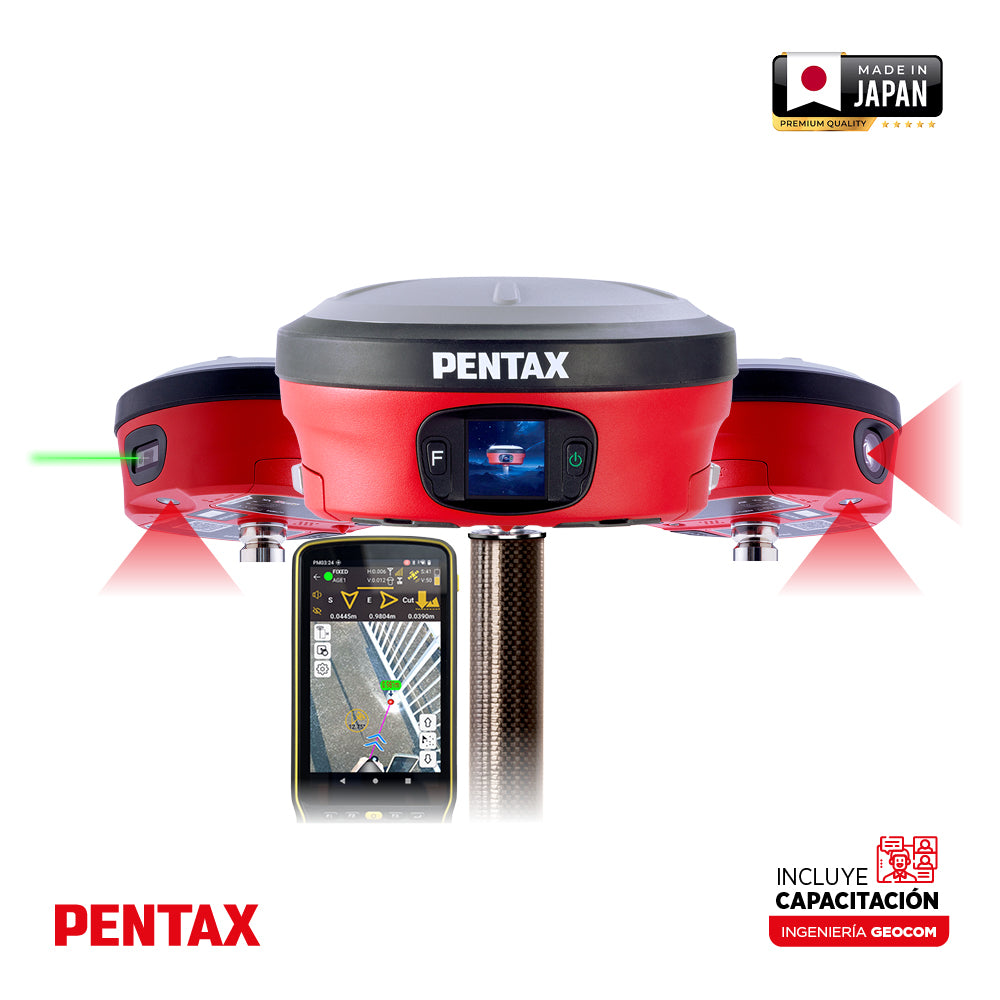

Pentax GX2 Series GNSS
PRECISION SATELLITE POSITIONING WITH EXTENDED FUNCTIONS
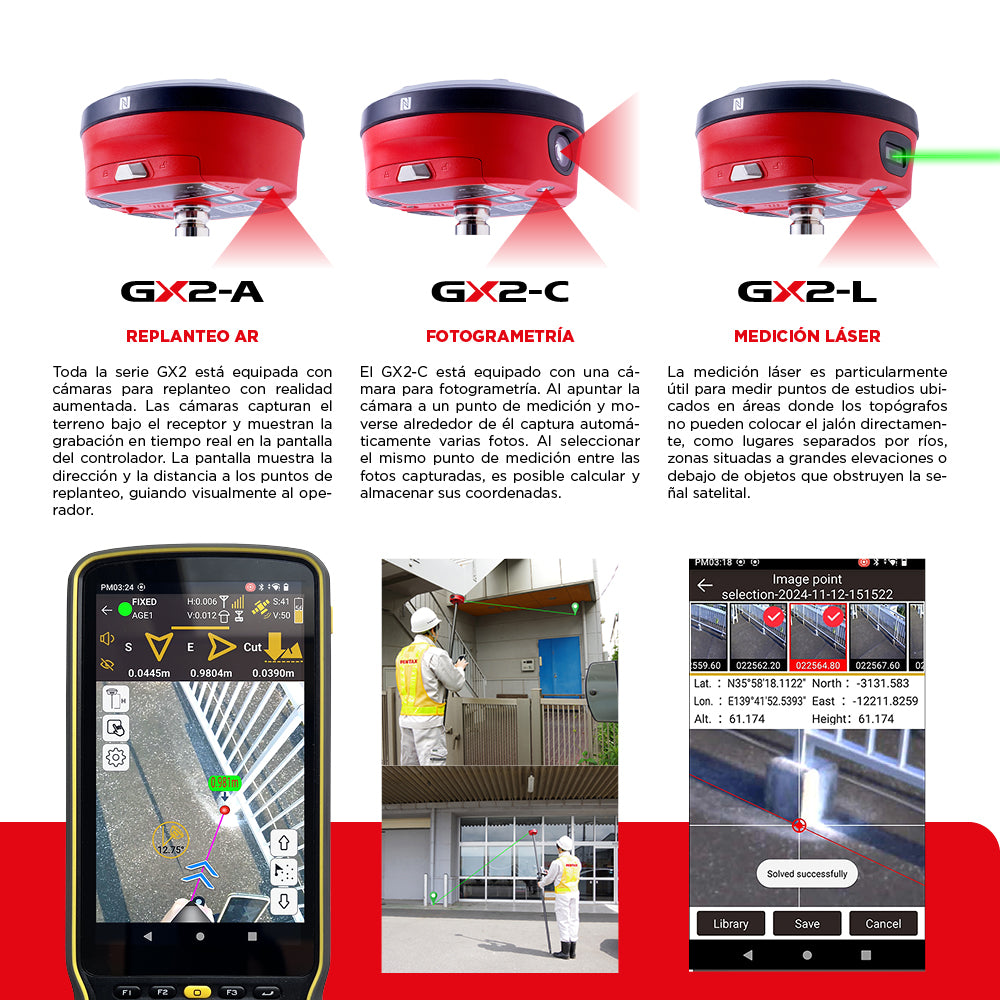
Pentax GX2-A | GX2-C | GX2-L
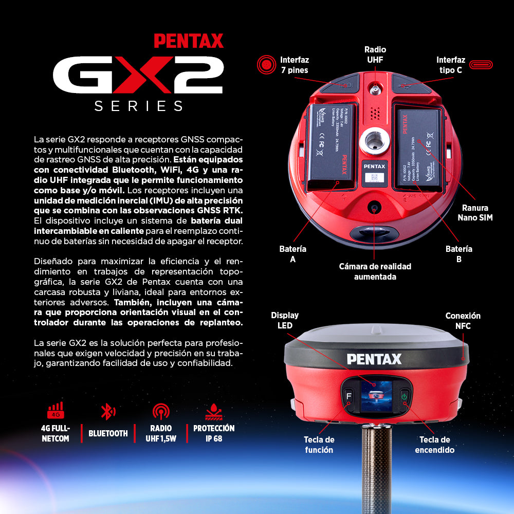
The GX2 series features compact, multifunctional GNSS receivers with high-precision GNSS tracking capabilities. They are equipped with Bluetooth, WiFi, 4G connectivity, and an integrated UHF radio, allowing them to operate as both a base and/or a rover. The receivers include a high-precision inertial measurement unit (IMU) that combines with GNSS RTK observations. The device includes a hot-swappable dual battery system for continuous battery replacement without needing to power off the receiver.
Designed to maximize efficiency and performance in topographic surveying, the Pentax GX2 series features a robust and lightweight housing, ideal for harsh outdoor environments. They also include a camera that provides visual guidance on the controller during stakeout operations.
The GX2 series is the perfect solution for professionals who demand speed and accuracy in their work, ensuring ease of use and reliability.
AR Stakeout (GX2-A/GX2-C/GX2-L)
The entire GX2 series is equipped with cameras for augmented reality stakeout. The cameras capture the terrain beneath the receiver and display real-time footage on the controller screen. The screen shows the direction and distance to the stakeout points, visually guiding the operator.
Photogrammetry (GX2-C)
The GX2-C is equipped with a camera for photogrammetry. By aiming the camera at a measurement point and moving around it, it automatically captures multiple photos. By selecting the same measurement point from the captured photos, it is possible to calculate and store its coordinates.
Laser Measurement (GX2-L)
Laser measurement is particularly useful for measuring survey points located in areas where surveyors cannot directly place the pole, such as places separated by rivers, areas situated at high elevations, or beneath objects that obstruct the satellite signal.
IMU Tilt Compensation
Automatic tilt compensation in a range of ±60°, eliminating the need to keep the receiver vertical. This reduces operational steps, improves work flexibility, and adapts to uneven terrain.
IP68 Protection
All electronic components are housed in a lightweight but robust magnesium alloy casing with an IP68 rating for water and dust resistance. This ensures stable operation in adverse weather conditions or dusty environments.
Hot-swappable Dual Battery System
The GX2 series features a hot-swappable dual lithium battery system, allowing for more than 20 hours of continuous uninterrupted operation. This makes it especially suitable for long-duration outdoor surveying work.
GX2 NTRIP Web Interface
The GX2 series features NTRIP, which enables RTK positioning using the internet. Its main function is to transmit real-time correction data (RTCM) that is compatible with GNSS rovers and RTK drones.
⨭Full GNSS
⨭Kit includes Pentax P600X Android controller
⨭IMU
⨭Assisted stakeout camera
⨭Rangefinder*
⨭Photogrammetry camera*
⨭4G Full-Netcom
⨭Bluetooth 5.0
⨭1.5W UHF Radio
⨭IP68 Protection

He also takes
-
Consulting
Our team is ready to help you overcome any challenge in your projects. We have specialists with real technical training, who will guide you to integrate the exact solution your operation needs. Get advice from us via WhatsApp here
-
After-sales (Support and Technical Service)
We provide immediate technical support through our engineers to advise you on using your equipment to its maximum potential. Contact us to schedule your Technical Support via WhatsApp, or visit our Specialized Support portal to resolve operational queries.
-
News
Always stay one step ahead with the latest innovations in geospatial technology. Learn about new product launches, exclusive events, and technical talks designed to optimize your solutions. Discover all our news on the GEOCOM Blog