Skip to content
  • Facebook
  • Instagram
  • YouTube
  • TikTok
  • LinkedIn

Welcome to our new website

October 8, 2026. Geospatial Seminar. Visit us!

Contact us via WhatsApp here

  • Products
  • Areas
  • We
  • News
  • Contact
Login
  • Facebook
  • Instagram
  • YouTube
  • TikTok
  • LinkedIn
Search
Geocom
  • Products Products
  • Areas Areas
  • WeWe
  • NewsNews
  • ContactContact
Search Login Cart 0
Cart

Your cart is currently empty.

  • Continue shopping
    Tax included and shipping calculated at checkout
    Subtotal
    0 CLP
    View cart
    Search

    Usamos cookies

    El sitio de GEOCOM utiliza cookies para ofrecer una mejor experiencia de usuario y realizar análisis.

    Home Search Store 0 Cart Login
    Bentley iTwin Capture Manage & Extract
    Bentley iTwin Capture Manage & Extract
    Bentley iTwin Capture Manage & Extract
    Bentley iTwin Capture Manage & Extract

    REALITY DATA AND ASSET EXTRACTION MANAGEMENT SOFTWARE

    Bentley iTwin Capture Manage & Extract

    Reality Data Management and Asset Extraction Software

    iTwin Capture Manage & Extract allows you to organize, catalog, verify, and adjust your reality data, regardless of size or type. In addition, the desktop application allows you to perform simple and complex measurements, extract features, and perform advanced analysis using any reality data.

    Available in perpetual version and annual Virtuosity subscription

    • Reality Data and Traditional GIS

    Scalable and independent of hardware and any post-processing software, iTwin Capture Manage & Extract allows you to take massive amounts of spherical images, planar images, oblique images, point clouds, and textured meshes, and combine them with traditional GIS resources, such as vector data, orthophotos, and raster images. Import reality data captured with land, mobile, and aerial mapping systems, taken on roads, railways, water and air, both indoors and outdoors, and above and below ground.


    • Visualize and Navigate

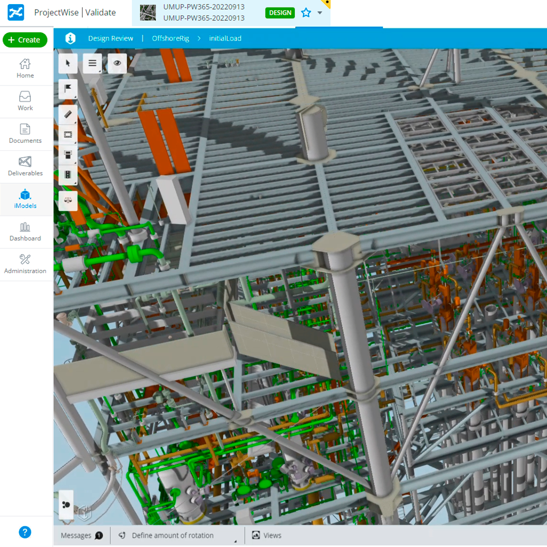
    View and navigate your mapping data in 2D or 3D, automatically play all compatible images, and overlay any vector data in 2D and 3D. iTwin Capture Manage & Extract allows you to configure various point cloud legend options, such as transparency and view depth. By defining point cloud display modes, you can view stereo, perspective, and isometric 3D views. You can also effectively overlay your point cloud data onto images with colorized cursor capabilities to detect underlying surfaces, reference the closest point, and interpolate between points to trace surfaces, edges, and corners.


    • Manage, Catalog, and Adjust Reality Data

    iTwin Capture Manage & Extract allows you to manage, catalog, access, adjust, and verify your reality data. Smart templates simplify and enable automation to import your reality data from any capture system and post-processing software. Verify and correct the accuracy of capture data with ground control points, trajectory adjustment, and tools for post-collection calibration. Catalog and organize your data, and then complete metadata and tagging to maintain an overview of your project, and gain easy access to any data at any time.


    • Extract Assets and Advanced Analysis

    iTwin Capture Manage & Extract allows you to perform simple and complex measurements, extract features, and perform advanced analysis. You can perform measurements with any reality data and extract them into GIS features.

    Create and verify your asset inventory. Perform manual, semi-automated, and fully automated measurements with point cloud data, in combination with object-oriented workflows and domain-specific analysis, such as bridge clearance, incompatibility detection, profiles and cross-sections, and road pothole analysis.

    • Teamwork with a Centralized Database

    Operators can work independently or collaborate to become efficient feature production teams.

    Team managers can configure their production unit, import reality data, prepare the feature extraction workflow, and manage workspaces for multiple operators.

    Extracted assets can be stored in the centralized database which provides real-time adjustments for all operators. Additional metadata, attribute information, documents, and photographs can be added or attached.

    Simple procedures maximize operator productivity. Team and user activity is recorded to create reports and gain insights to fine-tune your production.
    ⨭ Measure and extract features from images, point clouds, reality meshes, DEMs, and vector references
    ⨭ Measurements by point clouds, meshes, DEMs, reference planes, and forward intersection
    ⨭ Automatically recognizes points, surfaces, ridges, and corners.
    ⨭ Apply assisted and automated measurements
    ⨭ Use advanced tools for point cloud data feature extraction
    ⨭ Generate fast and efficient feature extraction workflows
    ⨭ Generate and export profiles and cross-sections
    ⨭ Automatic detection of poles and traffic signs
    ⨭ Create 2D floor plans
    ⨭ Calculate and report 2.5D volumes
    ⨭ GIS vector data toolbox
    ⨭ Save measurements to GIS and export to CAD

    Download Datasheet

    Formulario de cotización

    ¿Necesitas más información de un producto? ¿Quieres solicitar una demo? Completa el formulario con tus datos y nos pondremos en contacto.

    Characteristics

    iTwin Capture Manage & Extract allows you to organize, catalog, verify, and adjust your reality data, regardless of size or type. Additionally, the desktop application enables you to perform simple and complex measurements, extract features, and conduct advanced analysis using any reality data.

    Available as a perpetual license and annual Virtuosity subscription

    ● Traditional Reality and GIS Data: Scalable and independent of hardware and any post-processing software, iTwin Capture Manage & Extract allows you to take massive amounts of spherical images, planar images, oblique images, point clouds, and textured meshes, and combine them with traditional GIS resources, such as vector data, orthophotos, and raster images. Import reality data captured with terrestrial, mobile, and aerial mapping systems, taken on roads, railways, water, and air, both indoors and outdoors, and above and below ground.

    ● Visualize and Navigate: View and navigate your mapping data in 2D or 3D, automatically play back all compatible images, and overlay any 2D and 3D vector data. iTwin Capture Manage & Extract allows you to configure various point cloud legend options, such as transparency and view depth. By defining point cloud display modes, you can see stereo, perspective, and isometric 3D views. You can also effectively overlay your point cloud data onto images with colorized cursor capabilities to detect underlying surfaces, reference the closest point, and interpolate between points to track surfaces, edges, and corners.

    ● Manage, Catalog, and Adjust Reality Data: iTwin Capture Manage & Extract allows you to manage, catalog, access, adjust, and verify your reality data. Smart templates simplify and enable automation to import your reality data from any capture system and post-processing software.
    Verify and correct the accuracy of capture data with ground control points, trajectory adjustment, and tools for post-collection calibration. Catalog and organize your data, then complete metadata and tagging to maintain an overview of your project and gain easy access to any data at any time.

    ● Extract Assets and Advanced Analytics: iTwin Capture Manage & Extract allows you to perform simple and complex measurements, extract features, and conduct advanced analysis. You can take measurements with any reality data and extract them into GIS features.

    Create and verify your asset inventory. Perform manual, semi-automated, and fully automated measurements with point cloud data, in combination with object-oriented workflows and domain-specific analyses, such as bridge clearance, clash detection, profiles and cross-sections, and road pothole analysis.

    ● Teamwork with a Centralized Database: Operators can work independently or collaborate to become efficient feature production teams. Team managers can set up their production unit, import reality data, prepare the feature extraction workflow, and manage workspaces for multiple operators.

    Extracted assets can be stored in the centralized database, which provides real-time adjustments for all operators. Additional metadata, attribute information, documents, and photographs can be added or attached. Simple procedures maximize operator productivity. Team and user activity is logged to generate reports and gain insights to refine your production.

    Specifications

    ● Measure and extract features from images, point clouds, reality meshes, DEMs and vector references
    ● Measurements by point cloud, mesh, DEM, reference planes and forward intersection
    ● Automatically recognize points, surfaces, ridges and corners
    ● Apply assisted and automated measurements
    ● Use advanced tools for feature extraction from point cloud data
    ● Generate fast and efficient feature extraction workflows
    ● Generate and export profiles and cross sections
    ● Automatic detection of poles and traffic signs
    ● Create 2D floor plans
    ● Calculate and report 2.5D volumes
    ● GIS vector data toolbox
    ● Save measurements to GIS and export them to CAD

    Video
    Download Datasheet

    He also takes


    Do you need help?
    • Consulting

      Our team is ready to help you overcome any challenge in your projects. We have specialists with real technical training, who will guide you to integrate the exact solution your operation needs. Get advice from us via WhatsApp here

    • After-sales (Support and Technical Service)

      We provide immediate technical support through our engineers to advise you on using your equipment to its maximum potential. Contact us to schedule your Technical Support via WhatsApp, or visit our Specialized Support portal to resolve operational queries.

    • News

      Always stay one step ahead with the latest innovations in geospatial technology. Learn about new product launches, exclusive events, and technical talks designed to optimize your solutions. Discover all our news on the GEOCOM Blog

    view more products from Bentley
    WE
    • About us
    • Shipping and Warranties
    • Exchanges and Returns
    • Terms and Conditions
    • Whistleblowing Channel
    CONTACT

    Address | Av. Salvador 1105, Providencia.
    Phone | +562 2480 3600
    Email | ventas@geocom.cl

    GNSS and Optics Support | Whatsapp
    UAS Support |
    Whatsapp

    Geocom

    Subscribe to our newsletter

    • Facebook
    • Instagram
    • YouTube
    • TikTok
    • LinkedIn
    • Choosing a selection results in a full page refresh.
    • Opens in a new window.
    ¡Gracias por contactarte con nosotros! Soon an executive will contact you